Издательство: Просвещение
Год выпуска: 1981
Количество страниц: 200 с.
Ответственность: Ковальский Виталий Владимирович (Редактор), Олейников Борис Васильевич (Редактор)
Издательство: ЯФ СО АН СССР
Год выпуска: 1979
Количество страниц: 122 с.
Минералогия и геохимия кимберлитовых и трапповых пород : сборник научных трудов / Академия наук СССР, Сибирское отделение, Якутский филиал, Институт геологии ; ответственные редакторы: В. В. Ковальский, Б. В. Олейников. - Якутск : ЯФ СО АН СССР, 1979. - 111 с.
Издательство: Якутский филиал СО АН СССР
Год выпуска: 1981
Количество страниц: 52 с.
Издательство: Просвещение
Год выпуска: 1981
Количество страниц: 164 с.
Ответственность: Жилинский Г. Б. (Редактор)
Издательство: Наука, Сибирское отделение
Год выпуска: 1979
Количество страниц: 152 с.
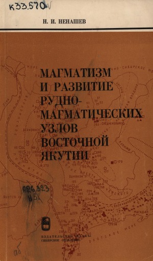
Ненашев, Николай Иванович.
Магматизм и развитие рудно-магматических узлов Восточной Якутии / Н. И. Ненашев ; ответственный редактор Г. Б. Жилинский ; Академия наук СССР, Сибирское отделение, Якутский филиал, Институт геологии. - Новосибирск : Наука, Сибирское отделение, 1979. - 142 с.
Издательство: Книжное издательство
Год выпуска: 1974
Количество страниц: 190 с.
Количество страниц: 6 с.
- Прикладные науки. Медицина. Ветеринария. Техника. Сельское хозяйство > Инженерное дело. Техника в целом > Строительство подземных сооружений. Земляные работы,
- Математика. Естественные науки > Общая геология . Метеорология. Климатология. Историческая геология. Стратиграфия. Палеогеография,
- НАУКА ЯКУТИИ > ПРИКЛАДНЫЕ НАУКИ. МЕДИЦИНА. ТЕХНИКА. СЕЛЬСКОЕ ХОЗЯЙСТВО > Инженерное дело. Техника в целом > Строительство подземных сооружений. Земляные работы,
- НАУКА ЯКУТИИ > МАТЕМАТИКА. ЕСТЕСТВЕННЫЕ НАУКИ > Геология. Геологические и геофизические науки.
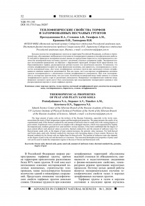
The large amount of peaty soils on the territory of the Russian Federation, especially in the Arctic zone, necessitates the study of their temperature regime and thermophysical properties. The paper presents the results of an experimental study of the thermal conductivity and amount of unfrozen water in sandy soils with varying degrees of peat content. Experiments were carried out on samples with a damaged structure, which were represented by slightly decomposed peat, medium-grained river sand and their various mixtures. It has been established that the degree of peat content affects such physical values as porosity, thermal conductivity and the amount of unfrozen water. For thawed peaty sandy soils, as the degree of peat content increases, the porosity value increases. For both thawed and frozen peaty sand soils, thermal conductivity decreases with increasing degree of peat content. Moreover, the thermal conductivity for frozen soils are higher than for thawed soils. The amount of unfrozen water also depends on the degree of peat in the soil and decreases as it increases. The measured thermophysical properties of peaty sand soil can be used to model the temperature regime in the area of frozen and thawed peat soils.
Теплофизические свойства торфов и заторфованных песчаных грунтов / Протодьяконова Н. А., Степанов А. В., Тимофеев А. М. [и др.] ; Институт физико-технических проблем Севера им. В. П. Ларионова // Успехи современного естествознания. - 2024. - N 1. - С. 52-57. - DOI: 10.17513/use.38207
DOI: 10.17513/use.38207
Количество страниц: 6 с.
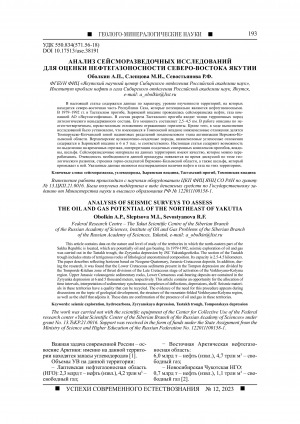
This article contains data on the nature and level of study of the territories in which the north-eastern part of the Sakha Republic is located, which are potentially oil and gas bearing. In 1979-1992, seismic exploration of oil and gas was carried out in the Tastakh trough, the Zyryanka depression by JSC Yakutskgeofizika. The section of the Tastakh trough includes strata of terrigenous rocks of lithological unconstrained composition. Its capacity is 2.5-4.5 kilometers. The paper describes reflecting horizons based on Neogene-Quaternary, Jurassic-Cretaceous deposits. In addition, during the research, it was found that the Lower Cretaceous sediments present in the Tompon depression are divided by the Tomporuk-Kitchan zone of thrust divisions of the Late Cretaceous stage of activation of the Verkhoyano-Kolyma region. Upper Jurassic volcanogenic sedimentary rocks, Lower Cretaceous coal-bearing deposits are contained in the Zyryanka depression at 6 and 5 thousand meters, respectively. This article contains an opportunity for the allocation of time intervals, interpretation of sedimentary synchronous complexes of deflections, depressions, shelf. Seismic materials in these territories have a quality that can be recycled. The evidence of the need for this procedure appears during discussions on the topic of geological development, the structure of the mountain-folded Verkhoyano-Kolyma region, as well as the shelf that adjoins it. These data are confirmation of the presence of oil and gas in these territories. The work was carried out with the scientific equipment of the Center for Collective Use of the Federal research center ҺYakut Scientific Center of the Siberian Branch of the Russian Academy of Sciencesһ under grant No. 13.TsKP.21.0016. Support was received in the form of funds under the State Assignment from the Ministry of Science and Higher Education of the Russian Federation No. 122011100158-1.
Оболкин, А. П. Анализ сейсморазведочных исследований для оценки нефтегазоносности северо-востока Якутии / Оболкин А. П., Слепцова М. И., Севостьянова Р. Ф. ; Институт проблем нефти и газа // Успехи современного естествознания. - 2023. - N 12. - С. 193-198. - DOI: 0.17513/use.38191
DOI: 10.17513/use.38191
Количество страниц: 8 с.
The northern slope of the Yakut uplift covers the North Aldan oil and gas bearing region and partially the Pre-Verkhoyansk and Vilyui oil and gas bearing regions. The potential oil and gas content of the Northern slope of the Yakut uplift is associated with a wide stratigraphic range of promising sediment complexes (Vendian-Cambrian, Permian-Triassic and Jurassic-Cretaceous). All these complexes have confirmed oil or gas occurrences of varying intensity. Terrigenous-carbonate formations of the Vendian-Cambrian complex are the most promising deposits in terms of oil and gas potential, confined to the lower part of the upper sub-suite of the Yudom formation of the Vendian. A relatively effective fluid seals for the Vendian hydrocarbons can be the variegated formation of the Lower Cambrian, composed of dense mudded-off carbonate rocks. The prospects of Permian-Triassic and Jurassic-Cretaceous sediment complexes will be determined by the absence or presence of zonal and local fluid seals, including non-traditional permafrost hydrate. Thus, several oil and gas complexes of different origin and with different types of fluid seals are identified in the section. A brief overview of the promising oil and gas complexes of the Northern slope of the Yakut uplift emphasizes the need for priority geological exploration for oil and gas. Clarification of geological structure of the studied area will make it possible to identify the most promising zones and sites for planning and organzing exploration work. The work was carried out with financial support within the framework of the State Assignment of the Ministry of Science and Higher Education of the Russian Federation No. 122011100158-1 using scientific equipment of the Center for Collective Use of the Federal research center "Yakut Scientific Center of the Siberian Branch of the Russian Academy of Sciences" within the framework of grant No. 13.TsKP.21.0016.
Калинин, А. И. Перспективные нефтегазоносные комплексы на северном склоне Якутского поднятия / Калинин А. И. ; Институт проблем нефти и газа // Успехи современного естествознания. - 2023. - N 12. - С. 185-192. - DOI: 10.17513/use.38190
DOI: 10.17513/use.38190

Количество страниц: 6 с.
The article is devoted to the ecological and geographical assessment of the territory of the republican resource reserve ҺTuostakhһ for tourist and recreational activities, which is located in the Verkhoyansk ulus of the Republic of Sakha (Yakutia) in the river basin. Tuostakh, on an area of 503530.0 hectares. Organized in 1997. During the study of the reserve, a comprehensive analysis of the natural, geomorphological, climatic, plant, animal and other features of the resource reserve was carried out. The regime of use of the reserve is considered, in particular the prohibited and permitted types of activities on their territory. It has been established that tourism activities are partly prohibited, which contradicts visiting the unique natural monuments located in this reserve, and in permitted activities, for example, gathering and fishing are permissible only for the local population, which in some way loses the tourist attractiveness of this area of nature, especially rich in berries, mushrooms and fish. The criteria for environmental sustainability of the reserve’s landscapes were assessed. The overall assessment of environmental sustainability was 9 points, which corresponds to environmentally unsustainable landscapes of protected areas. As a result of the research and assessments, some conclusions were developed on the territorial planning arrangement of the resource reserve, functional zones and their regimes, as well as on the joint coordinated work of state environmental authorities with tourism companies, which are currently operating on the territory of the resource reserve not agreed upon and not organized. Some recommendations are given when planning tourism in this unique area of nature.
Николаев, А. А. Эколого-географическая оценка ресурсного резервата "Туостах" для туристско-рекреационной деятельности / Николаев А. А. ; Северо-Восточный федеральный университет им. М. К. Аммосова // Успехи современного естествознания. - 2023. - N 12. - С. 140-145. - DOI: 10.17513/use.38184
DOI: 10.17513/use.38184